Introduction
In today’s data-driven world, geospatial databases are essential for efficiently managing and analyzing spatial data, enabling organizations to make informed decisions based on location-based insights. Companies like Uber and Google heavily rely on these databases to power their services.
Uber utilizes geospatial databases to optimize ride pricing and dispatch. To handle the vast amount of spatial data, Uber developed H3, a hexagonal hierarchical spatial index, which allows for efficient visualization and exploration of geospatial information. Uber’s real-time data platform, Gairos, processes over 1 million events per second and manages more than 1,500 terabytes of queryable data, highlighting the massive scale at which geospatial data is handled.
Google Maps serves millions of users worldwide, processing a substantial number of geospatial queries every minute. For example, the Geocoding API is rate-limited to 3,000 queries per minute, reflecting the high volume of requests managed by Google’s geospatial infrastructure. Additionally, the Maps JavaScript API allows up to 30,000 map loads per minute, demonstrating the platform’s capacity to handle extensive geospatial data requests.
These examples illustrate the critical role of geospatial databases in supporting large-scale, real-time applications, enabling companies to deliver efficient and reliable services to users worldwide.
Traditionally, for small to medium-scale geospatial applications that don’t require handling Petabytes of datasets, PostgreSQL, coupled with the PostGIS extension, has been the preferred database management system (DBMS) for GIS developers. The reasons behind this choice are its open-source nature, the extensive community support it enjoys, and its robust geospatial function library, which includes both 2D, 3D, and raster functions, along with comprehensive support for almost all spatial reference systems (SRS). However, as the demand for real-time processing of extremely large datasets has increased, even smaller companies are seeking alternative geospatial databases that can scale up and also have additional features.
The intent of this blogpost is to compare PostgreSQL/PostGIS and Kinetica from a functionalities point of view to help developers/architects choose the right tool for the right use case.
1. PostgreSQL/PostGIS
PostGIS is an advanced spatial database extender for PostgreSQL, transforming it into a powerful platform for managing, storing, and analyzing geospatial data. Whether you’re working with simple points or complex geometries(Multipolygons, MultipolygonZ, MultiLineString, GeometryCollection, etc.), PostGIS equips PostgreSQL with a robust suite of geospatial capabilities.
Key Features of PostGIS are:
1. Spatial Data Storage
PostGIS allows you to store diverse types of spatial data, including points, lines, polygons, and multi-geometries, in both 2D and 3D formats.
2. Spatial Indexing
Optimize the performance of geospatial queries with spatial indexing, enabling quick searches and retrievals based on location.
3. Spatial Functions
Leverage a comprehensive library of spatial functions for analyzing geospatial data. Perform tasks like measuring distances, calculating areas, intersecting geometries, buffering, and much more.
4. Geometry Processing
PostGIS provides tools for processing and transforming geometry data, such as simplification, conversion, and generalization, to meet a variety of use cases.
5. Raster Data Support
In addition to vector data, PostGIS supports raster data storage and processing. This makes it ideal for handling data like digital elevation models or weather imagery.
6. Geocoding and Reverse Geocoding
Easily convert addresses to geographic coordinates (geocoding) or derive addresses from coordinates (reverse geocoding) with built-in functions.
7. Integration with Third-Party Tools
PostGIS seamlessly integrates with popular geospatial tools like QGIS, GeoServer, MapServer, ArcGIS, and even data visualization platforms like Tableau, making it highly versatile and widely adopted.
Why Choose PostGIS?
Of-course, all above are mouthwatering functionalities for anyone trying to build geospatial applications. With its ability to handle complex geospatial operations, PostGIS is the backbone of many GIS applications, from urban planning and transportation logistics to environmental monitoring and disaster management. By extending PostgreSQL’s capabilities, PostGIS has become a go-to solution for developers, analysts, and GIS professionals around the world.
2. Kinetica
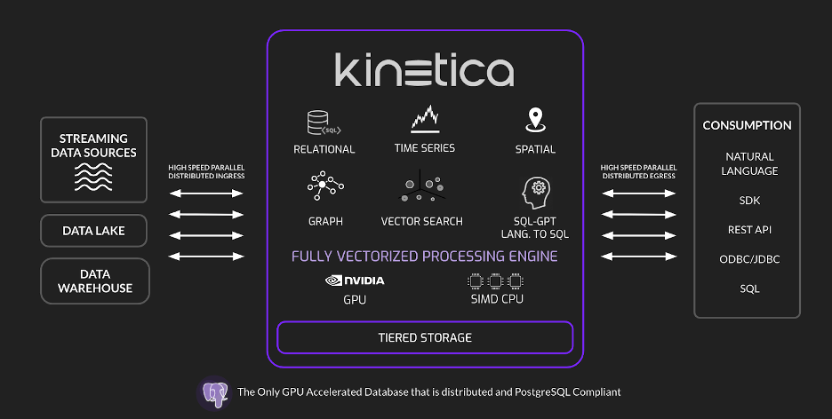
Kinetica DB stands out as a high-performance platform for geospatial analytics, offering a comprehensive suite of Geospatial and Geometry Functions to process, analyze, and visualize spatial data. Here’s an overview of the advanced geospatial capabilities Kinetica brings to the table:
1. Scalar Functions
These functions operate at the record level, allowing precise application of geospatial operations to individual data points in WKT (Well-Known Text) or X/Y coordinate formats.
2. Enhanced Performance Scalar Functions
Designed for speed and efficiency, these performance-optimized scalar functions handle geospatial computations specifically for X/Y data, delivering faster results for high-volume datasets.
3. Aggregate Functions
Aggregate functions enable geospatial analysis across groups of records, making it possible to derive insights from collections of data in WKT or X/Y coordinate formats. Ideal for summarizing spatial trends or patterns.
4. Track Functions
A unique offering for analyzing movement and temporal data, track functions combine scalar and aggregate functions to process track-based data, enabling advanced applications like route optimization or movement tracking.
5. H3 Functions
Native H3 support for geospatial indexing to apply gridding functions to spatial data. H3 functions work seamlessly with both WKT and X/Y data, enabling geospatial data aggregation, spatial indexing, and hexagonal grid-based analysis. Although, Kinetica does not provide any raster data management support which could be a deal-breaker for many since rasters are one of the only 2 GIS data types (other one is vector if you were wondering).
Key Differences Between Kinetica and PostgreSQL
When it comes to choosing a database management system (DBMS), Kinetica and PostgreSQL are two well-known options, each catering to distinct use cases. Here’s a detailed comparison of their key differences to help you understand which one aligns better with your needs:
- Data Management Approach
• Kinetica: Designed as a GPU-accelerated DBMS, Kinetica excels at real-time data analytics and visualization. Its GPU-powered architecture enables vectorization, tiered storage(hot storage and cold storage) and memory-first design. The GPU support comes in handy while performing complex table joins or on-the fly WMS tiles creation, avoiding the need to pre-tile datasets. Kinetica also supports sharding tables by means of shard keys which helps distribute the data on multi-node clusters allowing parallelization within and across nodes.
• PostgreSQL: A traditional relational database system, PostgreSQL stores data in tables and supports SQL for data querying and management. Combined with PostGIS extension, it acts as a powerful geospatial database which leverages all the core features of PostgreSQL database including comprehensive list of datatypes, parallelization of read queries, Multi-version concurrency control, table partitioning, security/authentication tools, stored functions, procedures and many more. Postgres marks as the benchmark for all the RDBMSs around many of which derive a lot of the features from this DB.
2. Scalability
• Kinetica: Kinetica effortlessly handles massive datasets and high workloads by distributing tasks across multiple servers. It can be deployed across different cloud platforms like Google Cloud and AWS where it can scale up horizontally and vertically.
• PostgreSQL: While PostgreSQL supports scaling through replication and sharding, it may not match Kinetica’s efficiency for extremely large datasets or high-concurrency scenarios. Although all major cloud providers like Google Cloud (with Cloud SQL for PostgreSQL), Amazon Web Services (AWS RDS for PostgreSQL), and Azure all offer robust support for PostgreSQL, allowing users to easily set up, manage, and scale their PostgreSQL databases within their respective cloud environments; essentially providing a fully managed PostgreSQL service in the cloud. On the other hand Kinetica is not as widely supported in terms of managed services in cloud.
3. Performance
• Kinetica: With GPU acceleration, Kinetica delivers exceptional performance for tasks like machine learning, geospatial analysis, and time-series data processing.
• PostgreSQL: Though reliable for traditional transactional workloads, PostgreSQL lacks the speed and optimization required for advanced analytical tasks, especially when dealing with high computational complexity.
4. Data Storage
• Kinetica: Uses a proprietary storage format optimized for GPU-based processing, ensuring faster data retrieval and computation.
• PostgreSQL: Employs a more traditional row-oriented storage format, which may be less efficient for analytical workloads requiring large-scale data scans.
5. Built-in Visualization Tools
• Kinetica: Comes with built-in visualization tools, enabling users to create interactive dashboards and visualizations directly from the database by means of their Reveal portal. Also via the Kinetica workbench, users can run SQL queries and quickly view resultant tables in the form of map, bar/pie charts, graphs, etc.
• PostgreSQL: While it can integrate with third-party visualization tools like Tableau or Power BI, PostgreSQL lacks native visualization capabilities. SQL IDEs like DBeaver, PgAdmin, etc. do have some visualization capabilities like mapping the gis vector features on OSM basemap, although they cannot handle thousands of gis features the way kinetica can do owing to it’s on the fly WMS tiles creation ability.
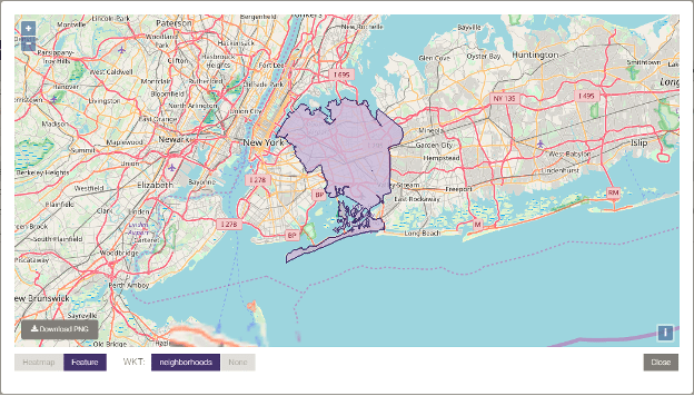
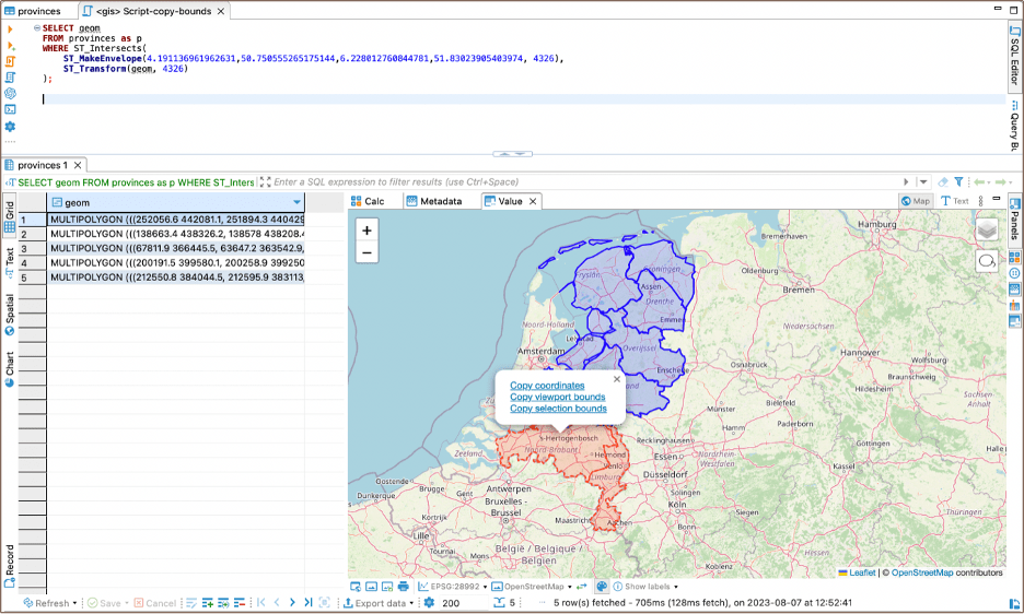
Provinces- Multi-polygons fetched from postgis table (source: Dbeaver official documentation)
6. Commercial Support and Licensing
• Kinetica: A commercial product with enterprise-grade support and licensing, making it ideal for organizations that prioritize stability and dedicated assistance.
• PostgreSQL: An open-source, community-driven DBMS, PostgreSQL offers flexibility but relies on community support or third-party vendors for commercial-grade assistance.
Summary:
When comparing PostgreSQL/PostGIS and Kinetica for GIS functionalities, it becomes evident that both database management systems cater to specific use cases and requirements.
PostgreSQL/PostGIS is a time-tested, versatile solution, ideal for small to medium-scale applications where open-source flexibility, extensive community support, and robust geospatial functions are key priorities. It serves as the backbone for GIS professionals who need a reliable and cost-effective database for geospatial analysis and storage.
On the other hand, Kinetica shines in high-performance, large-scale environments, offering GPU-accelerated processing, horizontal scalability, and built-in visualization capabilities. It is particularly suited for real-time analytics, machine learning, and geospatial applications requiring rapid computation on massive datasets.
Ultimately, the choice between PostgreSQL/PostGIS and Kinetica depends on your project’s specific needs. If your focus is on transactional workloads and affordability, PostgreSQL/PostGIS is an excellent choice. However, if your organization demands cutting-edge speed, scalability, and performance for real-time, data-intensive operations, Kinetica one of the better options out there.
Both tools bring immense value to the GIS ecosystem, and understanding their strengths and trade-offs will help you make the right decision for your geospatial projects.

Leave a comment